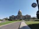
 BoiseBoise - capital of the state of Idaho and gateway to this state that is mostly (> 95%) wilderness. The state is in the Rocky Mountains region that stretches from USA to Canada. It forms a northern border with Canada and is sandwiched between the states of Montana in the east and Washington/Oregon in the west. | 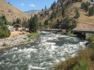 Payette River Scenic BywayFrom Boise, the Payette River Scenic Byway heads north on Idaho 55 to Horseshoe Bend where it meets the Payette River. From there, it passes through the Boise and Payette National Forests and the towns of Cascade and McCall before reaching the northern end of the byway at New Meadows. | 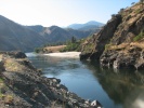 North of Payette River Scenic BywayThis stretch of US-95 north of New Meadows is not part of any scenic byway but it was scenic and historic (White Bird Battlefield) | 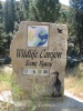 Wildlife Canyon Scenic BywayAs the name suggests, the Wildlife Canyon Scenic Byway presents the sight of numerous elk, mule deer, whitetail deer, chukars, wild turkeys, eagles, ospreys, cougars, bears and wolves. This byway connects the Payette River and Ponderosa Pine byways to form a nice trio of byways accessible from Boise. | |||
 Hells Canyon Scenic BywayHells Canyon is a 10-mile wide canyon located on the Idahos's western border with Oregon. It is North America's deepest river gorge at almost 8000 feet deep in some parts. The Snake River flows at the bottom and carved the canyon. Most of the area is inaccessible by road. A short stretch of paved road runs on the Idaho side of the river at the bottom of the canyon and forms the Hells Canyon Scenic Byway. One can access this section by paved highway from Boise or through dirt roads on the Seven Devils Mountain range. |  Ponderosa Pine Scenic BywayThis byway follows Route 21 from Boise, north to the historic mining town of Idaho City. Then it goes along the South Fork of the Payette River as it climbs northeast and then squeezes between two Idaho wilderness areas (Sawtooth and Salmon-Challis). After crossing Banner Summit (7056 ft.), it descends to the town of Stanley. | |||||